

Posts with tag 'Places to See in Central Oregon'
Subscribe and receive email notifications of new blog posts.
 RSS Feed
18
Hiking From Todd Lake to No Name Lake on Broken Top: A Classic Bend Adventure
Why This Hike Tops the List
If you're looking for a high-country hike near Bend that delivers big rewards without being an all-day grind, the Todd Lake to No Name Lake route is hard to beat. It's a staple for locals and a must-do for hikers visiting Central Oregon. Clear views, striking geology, and a turquoise lake tucked under Broken Top's cliffs—this trail earns every bit of its reputation.
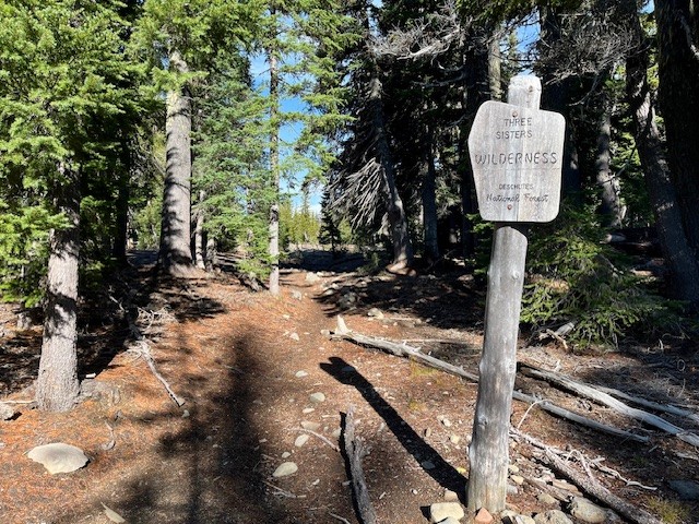
Trailhead: What to Know Before You Go
Todd Lake is the gateway to the high country and a gentle start to an otherwise rugged hike. Summer permits are required, and parking fills up early—no sense pretending luck will save you. Get there ahead of the crowd and you'll have a smoother day.
The hike begins with calm lakeside views, but you'll leave the easy terrain behind quickly. Plan for a steady climb and pack more water than you think you need. That rule never goes out of style in the Cascades.
 |
 |
The Ascent Toward Broken Top
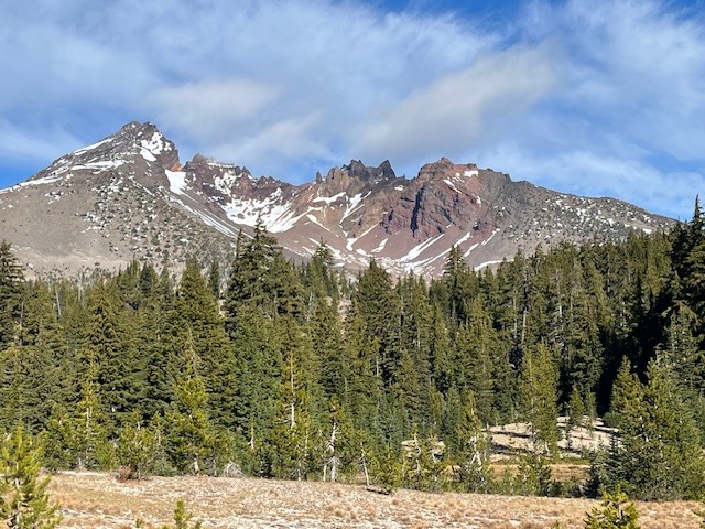
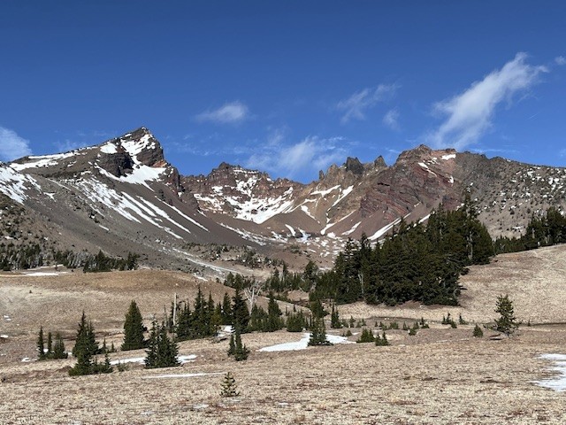
Once you climb out of the Todd Lake basin, the landscape immediately shifts. Broad alpine meadows open up with views that practically force you to stop. Wildflowers linger into late summer, and depending on the year, you might hit a few water crossings early in the season. Some are simple; some will test you and a short jaunt upstream may find a better crossing.
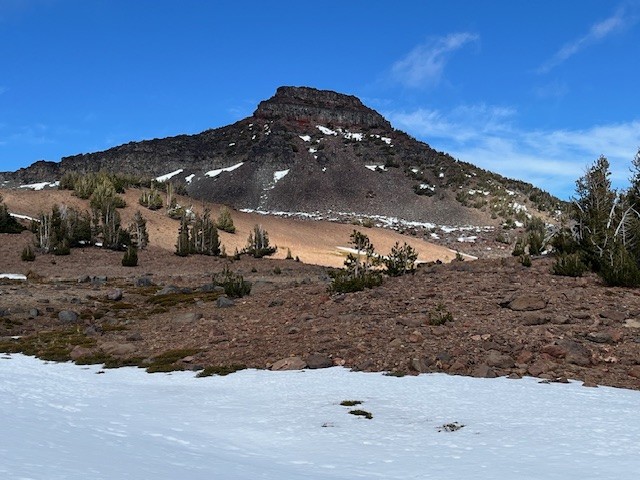
The trail continues uphill at a consistent grade—not brutal, but enough to remind you you're earning the views. As the trail climbs, you will see the bowl of Broken Top and Broken Hand next to Ball Butte.
 |
 |
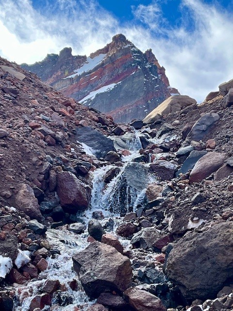
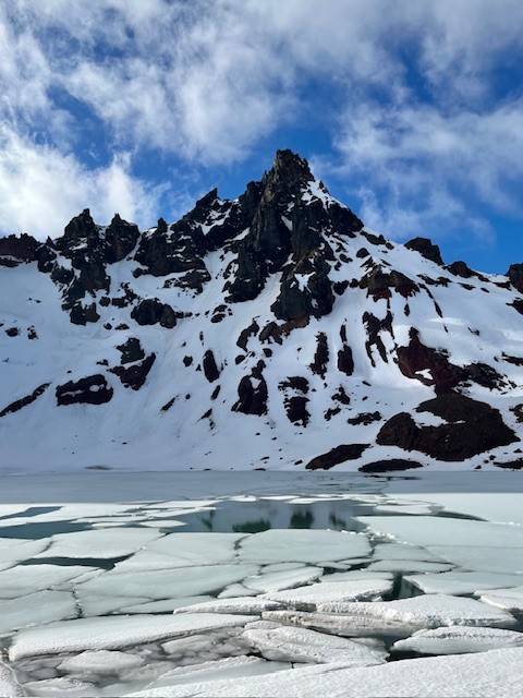
Arriving at No Name Lake
The payoff is no mystery. As soon as you crest that final rise, No Name Lake jumps into view with its glacial-blue water and the jagged summit of Broken Top looming overhead. It's dramatic, and it never gets old.
The wind at the lake can cut right through you, even on sunny days. Bring the extra layer. Most people wish they had. In mid November 2025, early snow melt can make for icy patches.
 |
 |
Optional Spur: The Ridgeline Viewpoint
If you've still got energy, take the short scramble above the lake. The vantage point gives you a panorama of South Sister, Mount Bachelor, Sparks Lake, and miles of wilderness you won't see from below. It's a quick effort with a huge return.
Heading Back
The descent is straightforward, but the dusty volcanic soil can get slick in summer. The meadows look completely different on the way down, especially in late-afternoon light, so the return trip isn't just a repeat.
Is This Hike Worth It? Absolutely.
There's a reason people go back year after year. It's not technical but the scenery is top-tier. For anyone seeking a dependable alpine hike near Bend with big visual impact, Todd Lake to No Name Lake delivers. The entire trip exceeds 13 miles round trip and over 2500 feet of elevation gain if the Ridgeline Viewpoint is included.
Thinking About Moving to Bend?
If exploring trails like this is the lifestyle you want more of, Bend makes it easy. The area combines year-round outdoor access with a strong community with great real estate opportunities for varied budgets and housing needs. Call us to keep up with local trails, Bend living tips, and Central Oregon real estate insights.
7
Bend Premier Real Estate | November 2025 Newsletter
What's in the November 2025 Bend Premier Newsletter?
- A Cooler Fall Market Emerges for Bend Home Sales
- Cranberry Orange Bread
- Preparing Your Home for Thanksgiving: Cleaning and Decorating Tips
- Fall Adventure on the Peter Skene Ogden Trail
- Top 5 Reasons to Hire a Real Estate Agent When You Sell
30
Fall Adventure on the Peter Skene Ogden Trail
Discovering Central Oregon's Hidden Waterfalls and Autumn Magic
There's nothing quite like fall in Central Oregon—the crisp air, golden larches, and that quiet sense of calm before winter settles in. This past weekend, we set out on one of the region's most beautiful hikes: the Peter Skene Ogden Trail, a forested path that winds along Paulina Creek between La Pine and Paulina Lake.
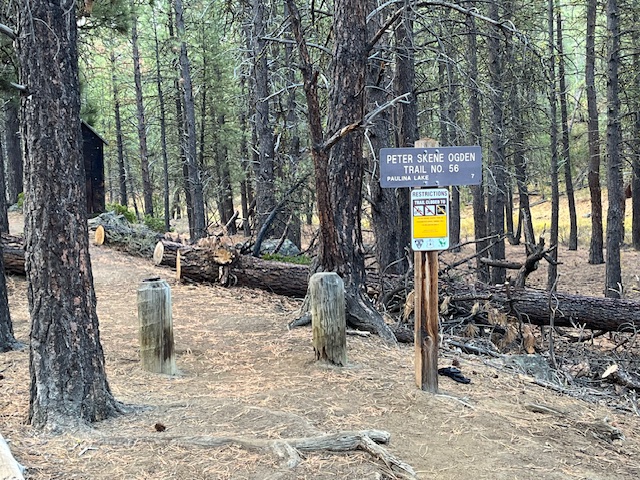 There's nothing quite like fall in Central Oregon—the crisp air, golden larches, and that quiet sense of calm before winter settles in. This past weekend, we set out on one of the region's most beautiful hikes: the Peter Skene Ogden Trail, a forested path that winds along Paulina Creek between La Pine and Paulina Lake.
A Trail Rich in Scenery and History
Named after early explorer Peter Skene Ogden, this trail follows the rushing waters of Paulina Creek through towering pines and volcanic rock formations. The moment you step onto the trailhead, you're greeted by the earthy scent of pine needles and the muffled sound of water tumbling in the distance—nature's invitation to slow down and explore.
Autumn Colors in Full Glow
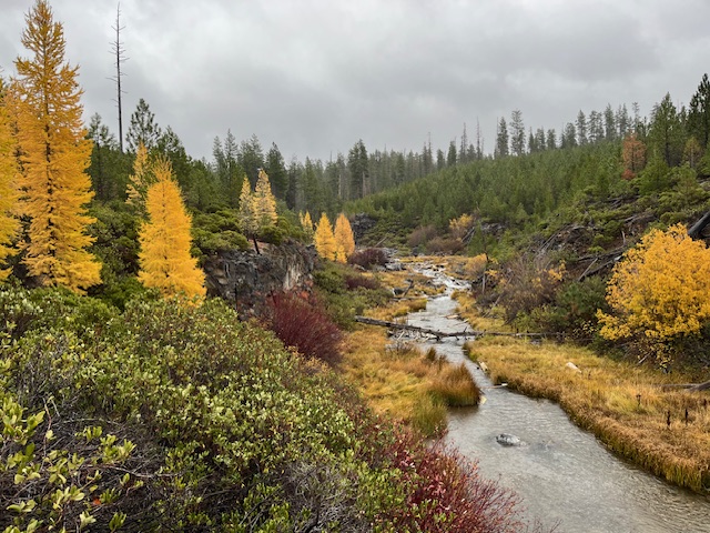
Mid-October is a spectacular time to visit. The larches were glowing gold, willows and huckleberries added bright pops of red, and the forest floor was carpeted in amber needles. Even under a soft drizzle, the landscape shimmered with color—proof that Oregon's magic isn't reserved for sunny days.
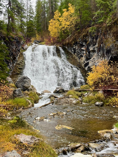
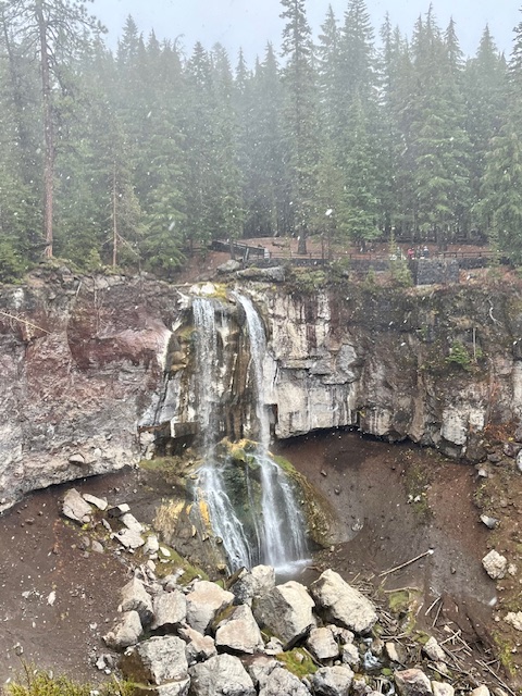
Waterfalls Around Every Bend
One of the highlights of the Peter Skene Ogden Trail is its string of waterfalls—each with its own character. Hikers can stop at several along the way:
- Lower Falls, where a broad curtain of water cascades dramatically over basalt cliffs.
- Paulina Creek Falls, a show-stopping finale that plunges nearly 80 feet into a rocky amphitheater below.
- And several smaller falls and pools in between, perfect for photos or a quiet break beside the creek.
 |
 |
Wooden bridges cross the stream at various points, offering postcard views and a chance to soak in the sound of rushing water echoing through the canyon.
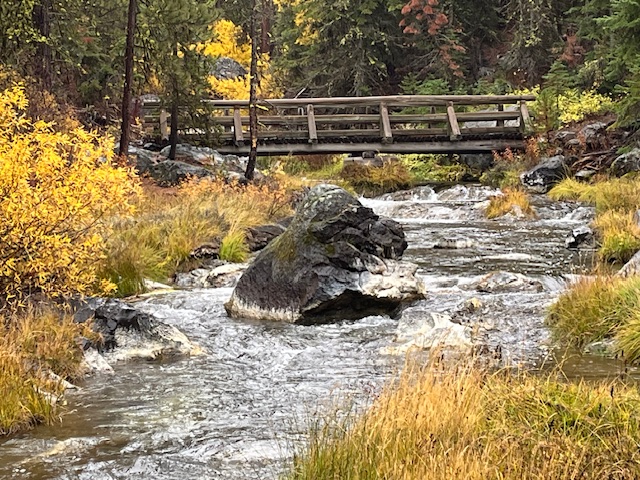 Wooden bridges cross the stream at various points, offering postcard views and a chance to soak in the sound of rushing water echoing through the canyon.
A True Central Oregon Gem
Whether you're a local looking for a quick escape or a visitor exploring beyond Bend, the Peter Skene Ogden Trail is a reminder of why we live here. It's less crowded than many popular Bend hikes, offers easy access to multiple waterfalls, and provides an ever-changing landscape from season to season.
If You Go
- Trailhead: Near McKay Crossing Campground (about 7 miles east of La Pine).
- Length: Roughly 7 miles one way to Paulina Lake, but you can hike shorter sections for a beautiful day trip.
- Best Season: Late spring through fall; expect snow at higher elevations by November.
- Tip: Bring layers, waterproof shoes, and a camera—you'll want to capture every turn of this gorgeous trail.
Why We Love Exploring Local Trails
Part of what makes Central Oregon special isn't just its homes and neighborhoods—it's the lifestyle that surrounds them. From mountain trails and alpine lakes to charming downtowns and cozy coffee shops, life here invites balance, adventure, and connection to nature.
21
A Perfect Day in Bend: How Locals Spend Their Weekend
Experience the Bend lifestyle through the eyes of those who call it home. From sunrise coffee and mountain views to riverside adventures and craft cocktails downtown, a weekend in Bend is about living fully — outdoors, connected, and inspired.
Morning: Coffee, Sunshine, and River Trails
 Bend mornings start early — not out of obligation, but out of excitement. The light over the Cascades is too beautiful to sleep through, and the smell of fresh-roasted coffee from local cafés is irresistible. Grab a morning latte at Sparrow Bakery, where locals linger ov...
8
Bend Premier Real Estate | October 2025 Newsletter
What's in the October 2025 Bend Premier Newsletter?
- Lower Mortgage Rates are Making a Difference
- Pumpkin Pancakes
- Get Spooky While Saving: Budget-Friendly Halloween Decor Ideas
- Carl Lake is a Little Known Hike
- 3 Advantages of Buying a Newly Built Home Today
Privacy Policy / DMCA Notice / ADA Accessibility